
Throughout the 18th and 19th centuries, Europe’s cartographers traded on their reputation for accuracy and detail at a time of huge societal change. But as demand grew for increasingly detailed maps of the world to support industrialisation at home and colonisation overseas, they didn’t always get it right.
For over a century, the Mountains of Kong festooned maps of Africa after the Scottish surgeon and explorer Mungo Park returned from an expedition in the 1790s and described them to his cartographer, James Rennell, as a possible source for the Niger river.
Rennell, who is buried in Westminster Abbey, dutifully produced two maps featuring this supposed mountain chain, extending it well beyond Park’s journey into areas he could never have seen. His maps were widely copied, and doubts only grew about the mountain range’s existence towards the end of the 19th century.
In 1887-88, a French military officer, Louis-Gustave Binger, undertook an expedition to the area and proved it didn’t exist. Yet, in my work as a professor of cartography, I was amazed to stumble upon a reference to “Kong Mountains, French W. Africa” in the index of the 1936 edition of The Oxford Advanced Atlas – almost 50 years after Binger’s expedition.
This underlines the lasting impact that maps have on how we see and understand the world. Mapmakers even enabled important early case law for the copyright protections that are being tested by AI today.
In 1785, London map publisher Robert Sayer sued his local rival John Hamilton Moore for copying his nautical charts – but the court ruled in favour of Moore. It found that earlier charts could be consulted and improved, provided the new work was not simply a “servile imitation” but an improvement on what came before.
This ruling has been cited as a defence of AI, which consumes huge quantities of copyrighted material, but which reconstitutes it in ways that don’t appear as direct imitations.
A breakdown of trust
There has always been a huge amount of trust placed in the technology used to make our maps, from the ancient Greek dioptra (a surveying instrument) to modern satellites. But that trust was brought into question recently when Google added generative AI to its Google Earth satellite image platform, making it possible to create convincing but fictional satellite images.
Rather than take Google’s suggestions to render historic buildings or a “lakeside dream home”, some users were quick to make and share worrying images including bombed suburbs, collapsed landmarks and burning oil refineries.
The outcry was vociferous – including from fact checkers such as BBC Verify. Within 24 hours, Google rolled back the tool, Nano Banana 2, and promised “stronger guardrails” in the future.

The controversy is, in part, a tribute to the deep level of confidence Google Earth has earned from its user base – among them, fact checkers, journalists and the open-source intelligence community who depend on Google’s satellite mapping tool to verify life-threatening events in near-real time, from floods to famines.
Satellite imagery is now a key part of the visual vocabulary of our 24-hour news cycle. Countless times each day, we consult a map on our phones or scroll past satellite imagery in a news feed. These images have become so commonplace because they can track wildfires, reveal the destruction of Gaza, or document US military action in Iran. They offer a god’s eye view of Earth.
‘A mirror of the real world’
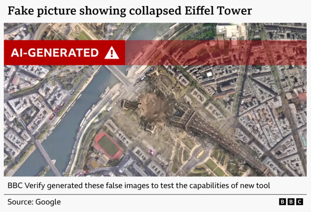
Journalists must act fast to verify and publish, which is why embedding generative AI within Google Earth was such a problem. Google stressed there would be an automatic AI watermark with every image generated – but this could be cropped out before sharing.
The process was also subtly different from requesting an entire image be created from scratch. In my test for this article, prompting ChatGPT to “generate a photorealistic satellite image of central London following a severe flood” appeared to return a plausible image.
Looking more closely, however, I could see that some buildings were misshapen and major roads were wonky. Verification against Google Earth (what else?) easily flagged these issues, so the image could safely be ignored and labelled a fake.
By uniting Google Earth with Nano Banana 2, genuine satellite images were being edited. If you wanted to collapse the Eiffel Tower, the points of reference around the disaster would still have aligned with the accredited source imagery. No oddities and errors would be found across the full image, thus providing much less for the fact checkers to go on when validating their sources.
BBC Verify/Google Earth
This validation process was used by the independent investigative journalism organisation Bellingcat to show that the Russian government had faked satellite imagery which suggested Malaysia Airlines MH17 had, in fact, been shot down by a Ukrainian fighter jet in July 2014. The headline of the Bellingcat article explaining its approach asked: “Who to trust, Google or the Russian MoD?”
Until the recent Google Earth AI furore, the answer to that question was in little doubt. As Google’s former geospatial technologist wrote: “We used to describe Google Earth and Maps as a mirror of the real world … That absolute bedrock of trust was structurally shattered this week.”
Our trust in maps has been built up over centuries. Trust in Google Earth has taken just two decades (it was originally launched as EarthViewer3D on June 11 2001 by a US tech startup that Google bought three years later). After countless pioneering refinements since the tool’s relaunch on June 28 2005, Google risked flooding the internet with more AI slop and fake images that run counter to what makes Google Earth, and maps in general, so valuable.
But Google’s rapid climbdown offers a welcome reminder about the values that have been at the heart of mapmaking throughout history. In the clamour to insert AI technology in every aspect of our lives, even the most evangelical tech companies still value trust above everything else.